Content
Home
Dutch Money
Gestalt Selectors List
One day I browsed my own web-pages and realized, although pictures of places around the world were available, the town I live in couldn't be seen!
So, one sunny Saturday morning in May 1997 I took my camera and took some pictures for the first time into the old, but charming, town centre.
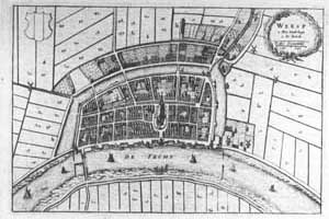
I was born and raised in Amsterdam but love made me eventually go to the small town of Weesp. It's an old fortified town (part of the New Dutch Water Defence Line and the Defence Line of Amsterdam) which lies on the crossroad of the rivers Vecht and Smal Weesp, and is even older than Amsterdam!
In the 17th and 18th centuries water boats would go to Weesp to get water from the Vecht and transport it to Amsterdam for beer-making and drinking water.
Weesp has a rich history of occupation and battles because it was on the border between the rivalry provinces of Holland and Utrecht.
The town also housed many breweries and distilleries together with a porcelain factory and later a chocolate factory.

Aerial picture by Otto Bodemeijer, Doc.centr. Stelling van Amsterdam.
The number of inhabitants was almost always between 1.000 and 1.500. It's no use pretending they had a nice life. They had their share of misery: wars, diseases, food shortages, floodings because of broken dikes, economic crisis, poor housing etc.
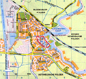
Nowadays (2010) about 17.621 people live, in MUCH better conditions, in Weesp. There are more people working than there are living in Weesp. Which is quite unusual for such a small town.
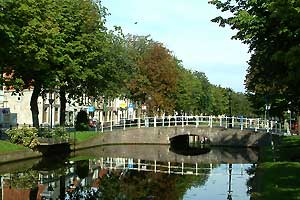
This picture was taken from the dam which forms the south-entrance into the old fortified town-centre (left).
There only remains an earth wall with some recent, concrete bunkers around part of the centre. On the right side of the defensive canal is the old road to the south (direction of Utrecht) following the river Vecht passing two windmills.
The houses are from wood, other materials weren't allowed, because when the area needed to be cleared to see the attackers, the wooden houses could easily be burnt down.
Until the early sixties of this century only wooden houses were allowed, after that concrete houses were allowed too. Which cleared the way for whole new parts of Weesp to be built.
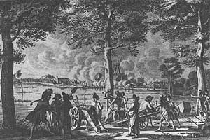
Drawing of the Prussians attacking Weesp in September 1787.
The main shopping street of Weesp which you can't see because of the blossoming chess nut trees.
From 1351 or earlier an earth wall with wooden fence was built on the right side of this canal.
Around 1400 it was replaced by a stone city wall to be demolished in the 17th century. From then on this canal was used to transport goods over water to the warehouses and companies. Today it's only in use by the swans and the ducks...
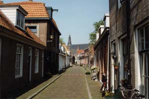
The Middenstraat ('middle-street') is one of the small roads in the old town centre. A fortified town had to use all the space available within the walls.
You are looking north to the Grote Kerk ('large church'), built between 1429 and 1462.
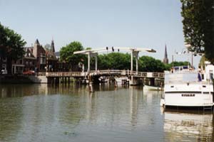
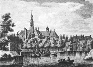
The only bridge (apart from a train bridge) for traffic crossing the river. The city lies wholly on the west bank (left) of the river and there are only a few houses and farms on the east side. Which was also the side most attackers used in the past so it wasn't wise nor allowed to live there.
Below is a drawing with the view from about the same point, with a different angle and bridge, in 1780.
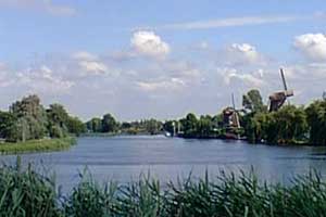
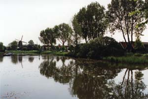
From one of the defensive earth walls you can see the river Vecht coming from the south with two of the three wind-mills of Weesp. The small one on the left is now used as a house, the other one still makes flour and is managed by volunteers.
During its history Weesp has seen a lot of windmills being build and destroyed. In 1668 there were 12 windmills in use.
Although I use the words 'river Vecht' it's not accurate. Which shouldn't be a surprise in a country with so much water and engineering works. The river no longer flows.
In the river is a lock before it 'flows' into the IJsselmeer (a lake which was called the Zuiderzee (Southern Sea) before a long enclosing dike was built across it in 1932) and is mainly used for drainage of rainwater. Before the lock was built, there was a dam upstream to regulate the water level, especially when areas were inundated to block attacking armies.
The river Vecht starts in the city of Utrecht as a branch of a branch of the River Rhine. In the 8th century the Vikings used it to go to the Utrecht area and wreak havoc.
René G.A. Ros
(Private email only! Business and hobby email via the concerned website only please.)
© 1995 - 2026, René G.A. Ros